England - Sep18 - Hadrian's Wall
|
| We drove up from Quarry Bank Mill in the rain to reach our B&B at Kellah Farm. It really was a farm, all by itself, in the rolling hills of north England. |
| |
 |
|
|
We had to drive a short distance a single lane road to get to the Kellah Farm. We had an excellent dinner at the nearby Castle House restaurant.
|
| |
 |
|
|
The next morning dawned with sunny, clear blue skies. It was a short drive to our first destination of the day: the Roman Army Museum.
Julius Caesar conducted expeditions to Britain in 55 and 54 BC but didn't establish a permanent Roman presence. He did enable bringing Britain's southern tribes into the orbit of Rome.
The Romans invaded Britain in AD 43, on the orders of the emperor Claudius. By AD 77, Roman armies controlled most of England. But whole tracts of Wales and northern England still required close military policing. Starting in AD 77, the governor of Britannia -- Julius Agricola -- brought Wales under control and moved north into Scotland, establishing a marching camp every 20 miles. Agricola's defeat of the Caledonian tribes at Mons Graupius in northeast Scotland in AD 83 essentiallly gave Rome control of the Scotland lowlands. But, in the words of the Roman historian Tacitus, ‘Britain was completely conquered and immediately neglected.’ The focus shifted to the great river frontiers of mainland Europe, where the threat to Rome seemed more pressing.
The Romans essentially withdrew to a line across the narrowest point of England which was only 87 miles wide and built Hadrian's Wall.
But later, they moved north again and build the turf and wood Antonine Wall which ran from modern-day Glasgow to Edinburgh. Construction began in AD 142 at the order of Roman Emperor Antoninus Pius, and took about 12 years to complete.
The Romans left Britain for good in AD 411.
|
| |
 |
|
|
The Roman Army Museum was very well done in a nice, modern facility. We watched excellent short movie on the life of a Roman Army soldier stationed up here at the end of the world.
|
| |
 |
|
|
A Roman Officer.
We learned all about life in the Roman Army, how it was organized, what it was like to be stationed up here in northern England.
|
| |
 |
|
|
A Roman Legionairre.
I couldn't get over how organized the Roman Army was. It was as professional a 20th century Army with doctrine, standard tactics, rules and regulations, career paths, you name it.
|
| |
 |
|
| A Roman Cavalryman. Notice, stirrups had not been invented yet. |
| |
 |
|
|
The next step was Vindolanda, an excavated Roman fort a few miles south of Hadrian's Wall.
|
| |
 |
|
|
This is what Vindolanda looked like back in the day. The Fort is to the right and surrounded by a wall with only four entrances. All Roman forts were laid out roughly the same. The Commanding Officer had his offices and quarters in the center.
A village sprung up to the left on the outside of the fort proper.
|
| |
 |
|
|
What Vindolanda looks like now. The Fort is on the far side.
|
| |
 |
|
| Lynnette and I walking to the excavated area. |
| |
 |
|
| As you can see, they have excavated quite a bit of it. |
| |
 |
|
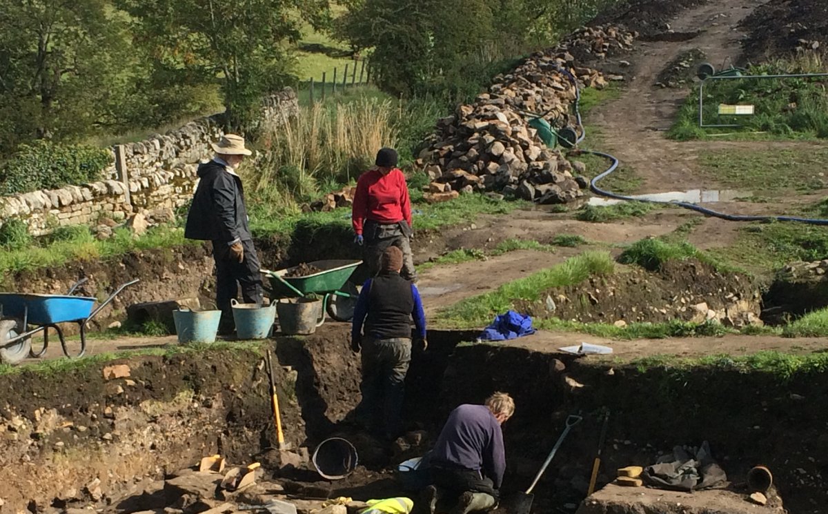
| We were lucky enough to arrive on their last day of the excavation season this year. |
| |
 |
|
|
Digging in the mud for Roman artifacts.
|
| |
 |
|
| A better look. |
| |
 |
|
|
On the other side were examples of the fort wall, first made out of wood.
|
| |
 |
|
| And then made out of stone. Roman soldiers would stand watch in the towers. |
| |
 |
|
| Looking down at the excavated areas from one of the towers. |
| |
 |
|
| Yep, it would be tough and costly for an attacker to get into a fort like this. Vindolanda was a permanent fort, as opposed to a "marching camp" which the Roman's built at the end of the day of marching. |
| |
 |
|
|
On the other side of the Fort was a museum where artifacts from the excavation were displayed. Of course, pottery is always big, because pottery doesn't rot or rust away like wood or iron.
|
| |
 |
|
|
An example of a Roman pottery kiln. Pretty primitive compared to what we saw at Ironbridge Gorge.
|
| |
 |
|
|
After Vindolanda, our next step was Hadrian's Wall itself. I've always been fascinated with the idea that the Romans had built a wall across the whole of northern England in AD 122. So here we were, finally getting to see it. Of course, it was an 87 mile long wall, so we would only get to see a section. We drove to a trailhead called Steel Rig which had a good-sized parking lot. From here you can hike along the wall as far as you want to go.
Here is the view from the parking lot.
|
| |
 |
|
|
And there it is in the background, Hadrian's Wall!
|
| |
 |
|
| It was a little cool at first. |
| |
 |
|
|
Hadrian's Wall is a World Heritage Site.
|
| |
 |
|
|
It was a short hike down to the wall.
Roman solders started building Hadrian's Wall in AD 122 and finished in AD 128.
|
| |
 |
|
|
A painting showing a centurion supervising the building of Hadrian's Wall. The centurion has been given the face of John Clayton, who was responsible for saving parts of the Wall from loss. The painting is in the collection at Wallington Hall near Morpeth, England.
|
| |
 |
|
|
Then up a hill.
|
| |
 |
|
| Looking west. That little square on the south side was a turret, used for observation and signalling. |
| |
 |
|
|
Looking west back at the parking lot which is under those trees to the right.
|
| |
 |
|
| Walking along the south side of the wall. Of course, it was much taller back in the day. Over the years, the stones from the wall were used for other things, including road-building in the 18th century. |
| |
 |
|
| A good look at the wall looking east. You can see how the Romans used the natural terrain to their advantage. |
| |
 |
|
| Looking east. That square to the south is larger than the one we saw earlier, and is one of the 80 small gated "milecastles" 9or fortlets) placed every Roman mile, holding a few dozen troops each. A pair of the turrets would be evenly spaced between the milecastles. |
| |
 |
|
|
Looking north. I wondered what a Roman sentry standing watch back through the first four centuries must have thought as he looked north into the lands of the barbarians. It probably looked very close backed then to what it does now.
|
| |
 |
|
| Down by the Milecastle. I suspect there was a substantial door at the wall-side entrance to the milecastle. |
| |
 |
|
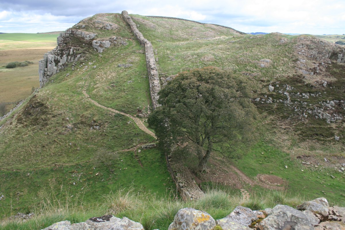
| This area is known as Sycamore Gap. The location was used in the filming of the 1991 movie Robin Hood: Prince of Thieves with Kevin Costner. The big sycamore tree has been called the Robin Hood tree ever since. |
| |
 |
|
| Still looking east. Beautiful country. |
| |
 |
|
|
I only hiked a half a mile along the wall. I would have liked to go farther but we didn't have the time. Now I am heading back..
|
| |
 |
|
| Still heading east back to the parking lot. |
| |
 |
|
|
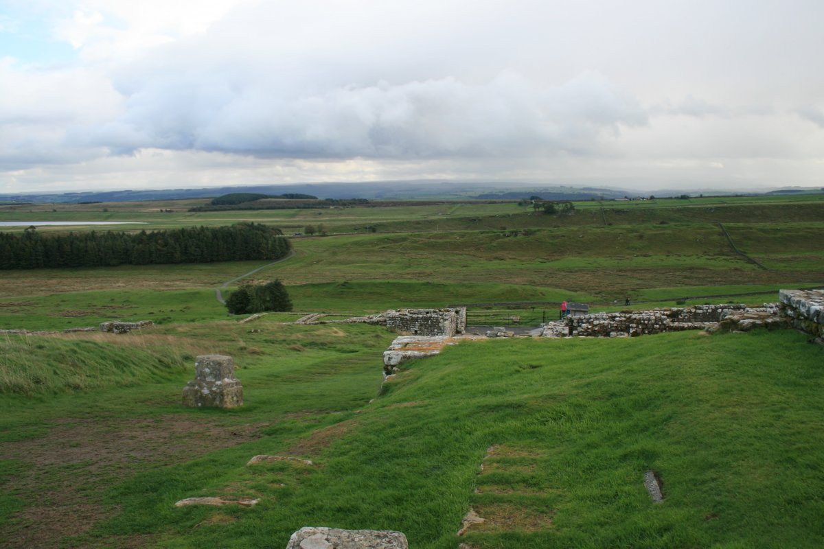
We headed west to Housesteads Roman Fort which, unlike Vindolanda, was directly alongside the wall. The parking lot and visitors center were at the bottom of a hill. I hiked up the hill to get to the Fort and a small museum.
|
| |
 |
|
|
What the Housesteads Fort looked back in its prime. Hadrian's Wall runs left to right at the top of the fort.
|
| |
 |
|
|
Looking from the Fort down the hill. The fort's excavation is done and no longer in process.
|
| |
 |
|
| By this time we had seen enough Roman walls, ruins and artifacts and it was time to move on. We continued west to Durham. |
| |
 |
|
| |
| |
|
|
|
|
|
|